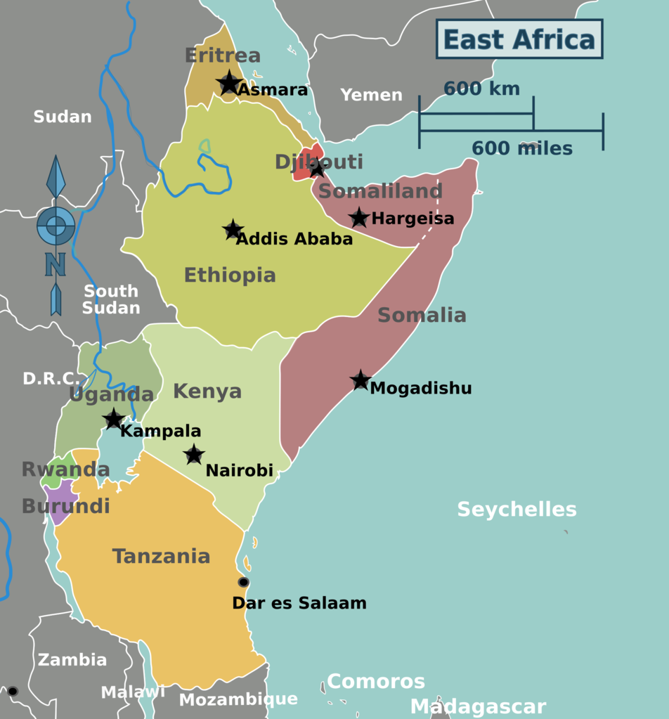
File:East Africa regions map.png

Size of this preview: 558 × 600 pixels. Other resolutions: 223 × 240 pixels | 446 × 480 pixels | 714 × 768 pixels | 952 × 1,024 pixels | 1,998 × 2,148 pixels.
Original file (1,998 × 2,148 pixels, file size: 502 KB, MIME type: image/png)
Summary
| Description | East Africa regions map for use on Wikivoyage, English version |
| Date | |
| Source | Own work based on the blank worldmap |
| Author | Peter Fitzgerald, amendments by Burmesedays |
| Other versions |
.png)
.png)
Licensing
This file is licensed under the Creative Commons Attribution-Share Alike 3.0 Unported license.
- You are free:
- to share – to copy, distribute and transmit the work
- to remix – to adapt the work
- Under the following conditions:
- attribution – You must give appropriate credit, provide a link to the license, and indicate if changes were made. You may do so in any reasonable manner, but not in any way that suggests the licensor endorses you or your use.
- share alike – If you remix, transform, or build upon the material, you must distribute your contributions under the same or compatible license as the original.
Original upload log
| This file was imported from Wikivoyage WTS. |
The original description page was here. All following user names refer to wts.wikivoyage-old.
- 2008-08-19 04:38 (WT-shared) Peterfitzgerald archive copy at the Wayback Machine 1402×3034 (667877 bytes) {{Imagecredit|credit=Peter Fitzgerald|captureDate=18 August 2008|location=Africa|source=[[:Image:East Africa regions map.svg]]|caption=East (Import from wikitravel.org/shared)
- 2008-08-19 04:42 (WT-shared) Peterfitzgerald archive copy at the Wayback Machine 1402×3034 (658074 bytes) fix titlebox (Import from wikitravel.org/shared)
- 2008-08-19 04:44 (WT-shared) Peterfitzgerald archive copy at the Wayback Machine 1402×3034 (662087 bytes) huh? (Import from wikitravel.org/shared)
- 2008-08-20 23:05 (WT-shared) Peterfitzgerald archive copy at the Wayback Machine 1402×3034 (658894 bytes) correcting errors (Import from wikitravel.org/shared)
- 2010-01-29 21:22 (WT-shared) Peterfitzgerald archive copy at the Wayback Machine 1611×2800 (816146 bytes) update to reflect changes to hierarchy (Import from wikitravel.org/shared)
- 2010-01-29 21:27 (WT-shared) Peterfitzgerald archive copy at the Wayback Machine 1611×2800 (816105 bytes) (Import from wikitravel.org/shared)
- 2011-07-11 02:06 (WT-shared) Burmesedays[dead link] 159×258 (37772 bytes) minus Malawi as per en region change (Import from wikitravel.org/shared)
- 2011-07-11 04:08 (WT-shared) Burmesedays[dead link] 1500×2439 (723855 bytes) sizing (Import from wikitravel.org/shared)
- 2011-07-19 02:18 (WT-shared) Peterfitzgerald archive copy at the Wayback Machine 1500×2440 (738977 bytes) S Sudan/Sudan split (Import from wikitravel.org/shared)
File history
Click on a date/time to view the file as it appeared at that time.
| Date/Time | Thumbnail | Dimensions | User | Comment | |
|---|---|---|---|---|---|
| current | 18:28, 10 September 2017 | | 1,998 × 2,148 (502 KB) | Ypsilon from Finland | Somaliland as a separate entity. |
File usage
The following page uses this file: